Cyclone Akvan strengthens to severe storm: red warning for Sri Lankan fishermen, Andhra Pradesh landfall expected
Akvan is about 650km north-east of Trincomalee and poses no landfall risk to Sri Lanka, but rough seas have led to red warnings for fishing and naval activity off the north and east coasts.
LSN Sri Lanka ·
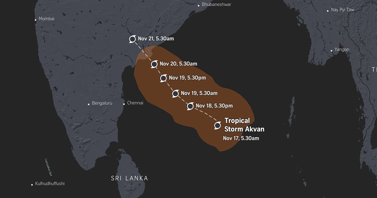
<p>Cyclone Akvan in the Bay of Bengal has intensified into a Severe Cyclonic Storm, according to the latest bulletins issued this morning (November 18, 2026) by the India Meteorological Department (IMD) and Sri Lanka's Department of Meteorology.</p>
<p>Although there is no risk of the cyclone making landfall in Sri Lanka, it is having a serious impact on fishing and naval activity in the seas around the island.</p>
<p>Where Akvan is now</p>
<p>According to IMD data, at around 5.30am today the system was centred near latitude 12.7°N and longitude 85.5°E. That places it:</p>
<p>About 650km north-east of Trincomalee<br>
About 580km east of Chennai<br>
About 610km south-southeast of Machilipatnam and Visakhapatnam</p>
<p>Over the past six hours the system has moved very slowly north-northwest at about 3km per hour.</p>
<p>Impact on Sri Lanka: red warnings for the fishing sector</p>
<p>Because the cyclone is moving towards India about 650km from Trincomalee, no direct landfall or extremely severe wind and rain is expected on the island. The public should, however, be aware of the following indirect effects.</p>
<p>Seas and fishing (the most serious risk): Red warnings have been issued for multi-day fishing vessels operating in the west-central Bay of Bengal, and for the sea areas off the coast from Kankesanthurai through Trincomalee and Batticaloa to Pottuvil.</p>
<p>These seas may be rough to very rough, with wind speeds of 30-40km per hour rising to as much as 60km per hour at times. Fishing and naval communities have been told to refrain completely from operating in the sea areas between latitudes 6°N-19°N and longitudes 80°E-95°E, and in the coastal waters listed above, until further notice. Vessels already in those areas should head to safe locations immediately.</p>
<p>Rain: Mainly dry weather will prevail over most of the island. Showers or thundershowers may occur at a few places in the Uva and Southern provinces and the Ampara district in the afternoon or at night. Light showers are also possible at some places in the Western, Sabaragamuwa and North Western provinces and the central hills, but heavy or prolonged rain is not expected.</p>
<p>Mist and air quality: Changes in wind direction caused by the cyclone are increasing mist and reducing air quality in parts of the island, including Colombo. Mist may also form in the early morning, and the public is asked to take precautions against temporary strong winds and lightning during thundershowers.</p>
<p>Landfall and impact on India</p>
<p>Weather experts say the chance of Akvan developing into a "Very Severe Cyclonic Storm", as earlier expected, has now fallen. Because the cyclone is moving slowly and losing intensity, the damage may be lower than previously forecast.</p>
<p>Landfall: Akvan is expected to cross the coast between Andhra Pradesh and Yanam (between Nellore and Visakhapatnam) as a severe cyclonic storm at around noon on November 20, with maximum sustained winds of 100-110km per hour gusting to 120km per hour.</p>
<p>Heavy rain and storm surge: Extremely heavy rainfall of more than 21cm is expected at some places in coastal Andhra Pradesh on November 19 and 20. Light to heavy rain is also possible in south coastal Odisha and in northern Tamil Nadu around Chennai. There is also a risk of a storm surge of 1 to 1.5 metres in low-lying coastal areas.</p>
<p>However, the impact is expected to be smaller than that of earlier cyclones such as "Arnab" and "Murasu", which affected Odisha.</p>
<p>Translated from the LSN Sinhala edition.</p>