How a new low-pressure system over the Andaman Sea could affect Sri Lanka
According to a Meteorology Department advisory issued on the morning of 13 November, showers or thundershowers are expected in coastal waters from Kankesanthurai to Galle via Trincomalee, Batticaloa and Hambantota. North-easterly winds around the island are 20–30 kilometres an hour, at times up to 45, and the sea may at times be fairly rough. With thundershowers, temporary gusts could reach 60–70 kilometres an hour and the sea could become very rough. Fishing and shipping communities have been advised to follow future forecasts and notices closely.
LSN Sri Lanka ·
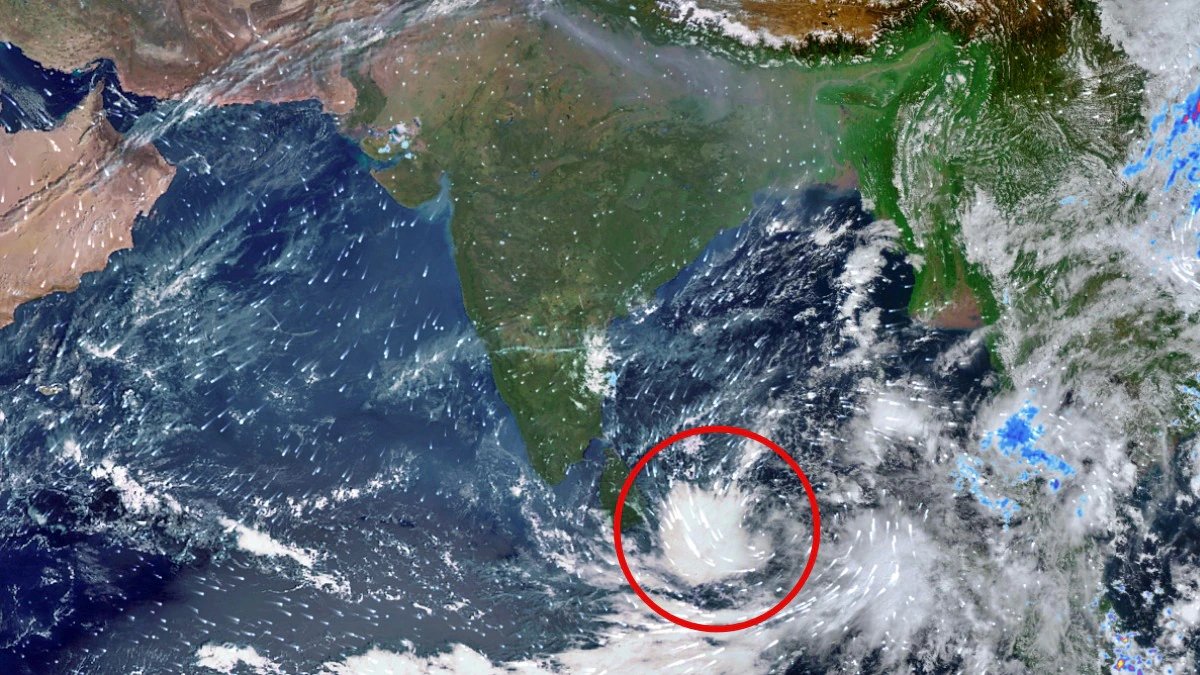
<p>A new rain-bearing system with intense cloud activity over the Andaman Sea and the south-eastern Bay of Bengal was captured on 13 November 2026 by the Indian Space Research Organisation’s (ISRO) INSAT-3DS satellite. Both the India Meteorological Department (IMD) and the Sri Lanka Department of Meteorology have been monitoring the system since it was identified.</p>
<p>Warnings have subsequently been issued that the system could become a depression by 15 November.</p>
<p>According to the IMD, a low-pressure area formed over the south-eastern Bay of Bengal on the morning of 13 November at about 5.30am, under the influence of an upper-air cyclonic circulation over the central Andaman Sea and around the Andaman and Nicobar Islands. Satellite thermal infrared images clearly show large cloud build-ups over the southern Bay of Bengal, the Andaman Sea and neighbouring areas.</p>
<p>The IMD expects the system to move north-westwards, become a well-marked low-pressure area around 14 November, and possibly intensify further into a depression in the same region on 15 November. Further intensification over the next 48 hours will depend on atmospheric and oceanic conditions. It has not been confirmed at this stage that the system will become a cyclonic storm.</p>
<p>Wind and sea conditions indicated in the source include squally weather over the Andaman Sea on 13–14 November, with winds of 40–50 kilometres an hour, gusting to 60; similar conditions over the south-eastern Bay of Bengal between 13 and 16 November; winds of 45–55 kilometres an hour, gusting to 65, over the south-western Bay of Bengal on 15–17 November if the system intensifies; and similar winds over the central Bay of Bengal on 16–17 November.</p>
<p>According to the Sri Lanka Meteorology Department advisory issued on the morning of 13 November, showers or thundershowers are expected in coastal waters from Kankesanthurai to Galle via Trincomalee, Batticaloa and Hambantota. North-easterly winds around the island are 20–30 kilometres an hour, at times up to 45, and the sea may at times be fairly rough. When thundershowers occur, temporary gusts could rise to 60–70 kilometres an hour and the sea could become very rough. Fishing and shipping communities have been advised to follow future forecasts and notices closely.</p>
<p>Meteorology Department Director General Ajith Wijemanne said earlier, around 10 November, that the system’s impact on the island could be felt on 15, 16 and 17 November. Rainfall could increase in particular in the Northern, North-Central and Eastern provinces. He also stressed that the impact could intensify if the system becomes a depression and moves north along the east coast. The department said the data were not yet sufficient to issue a more precise forecast, and that it would study the system further and issue any necessary warnings.</p>
<p>Combined with the current second inter-monsoon conditions and above-average rainfall expected in November, the system could somewhat increase showers over many parts of the island. Heavy rain exceeding 100 millimetres is possible in some places, including in the Western, Sabaragamuwa, Central, Southern and Uva provinces, and there is also a risk of temporary strong winds and lightning. The risk of sudden flooding from short, heavy showers because of blocked drainage, especially in urban areas such as Colombo, should also be considered.</p>
<p>Advisories have already been issued for marine activity, and multi-day deep-sea fishing vessels and shipping crews need to pay special attention.</p>
<p>Fishing and shipping communities have been told to limit activity in the relevant sea areas and to follow further notices. The public has been asked to be careful of lightning and temporary strong winds during thundershowers. Residents in low-lying areas and landslide-prone areas should monitor warnings. Officials have also asked the public to check the Meteorology Department’s official website and notices frequently.</p>
<p>Specialists in the field say that, because the system is still in a developing stage, its track and intensity can change from day to day.</p>
<p>Translated from the LSN Sinhala edition.</p>