World · Sri Lanka Bureau
UN adopts new world map correcting Africa's geographical representation
The United Nations has voted to adopt a revised world map that more accurately depicts Africa's true size, addressing long-standing cartographic distortions that have misrepresented the continent's land area for centuries.
LSN Sri Lanka ·
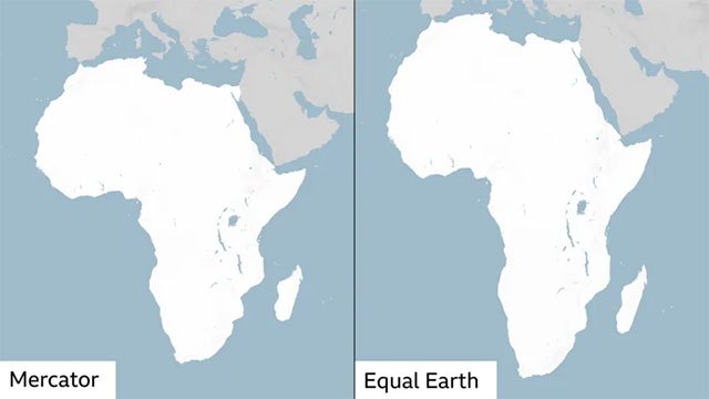
The UN General Assembly has approved the adoption of a new world map designed to correct historical geographical inaccuracies that have systematically understated Africa's continental dimensions. The decision marks a significant shift in how the world's second-largest continent will be officially represented in international forums and educational materials.
Traditional map projections, particularly the widely-used Mercator projection developed in the 16th century, have distorted Africa's size relative to other continents. The Mercator system, designed for maritime navigation, exaggerates landmasses closer to the poles while reducing those near the equator, resulting in Africa appearing substantially smaller than its actual area of approximately 30.4 million square kilometers.
The new cartographic standard provides a more proportionally accurate representation of Africa compared to other continents and regions. This correction carries symbolic importance alongside its practical applications, as decades of misrepresented maps have influenced perceptions of African geography and contributed to misconceptions about the continent's scale and significance on the global stage.
The adoption reflects growing recognition among UN member states of the importance of accurate geographical representation in fostering informed international discourse. Educational institutions, government agencies, and media organizations are expected to gradually transition to maps employing the updated standard, though the full implementation of this change across all sectors will likely take considerable time.